
Night Time Lights (NTL) is a class of satellite observations and derived products based on the detection of anthropogenic lighting present at the earth’s surface. Night Time Lights (NTL) Remote Sensing (NLRS) means acquiring visible light at night of land/water in cloudless conditions. A unique measure of the lightning brightness of the earth is observed with the help of Night Time Lights (NTL) datasets from space during the nighttime. In conjunction with other Earth observations satellite datasets, the new and better sensors, algorithms, and products for nighttime lights provide significant potential for a comprehensive understanding of human activities and related environmental repercussions in a constantly changing world due to various reasons. This particular section provides an insight into the major available Nighttime Satellites/Sensors.
Defense Meteorological Satellite Program – Operational Linescan System (DMSP-OLS)
Since the 1970s, the Defense Meteorological Satellite Program (DMSP) program handled by the U.S. Air Force has successfully captured emissions at nighttime from human settlements all around the world. The DMSP program was earlier developed for Defense purposes specifically for the US army but later it was also used for Nighttime Light detection purposes. DMSP-OLS has a peculiar and distinctive capability to acquire/capture low-light imaging data of the earth at night. This long-term satellite series has acquired Night Time Lights (NTL) over few decades, this has helped focus research trends and methods in various fields of studies and has been exploited widely by numerous scientists and a community of researchers.
Night Time Lights (NTL) data have been acquired from the series of nine satellites ranging from F10 to the F18 series. From these satellites, many datasets are produced which also includes the stable lights data product using DMSP. The obtained data is useful in the estimation of population density in urban and rural areas, human settlements monitoring, identifying the human-related activities, environmental emissions, electricity consumption, disaster monitoring and risk assessment, military actions, light detection from fishing vessels, and various related applications. Currently, three major sets of DMSP-OLS-derived data ranging from daily images to annual composites are commonly used in Night-Time Lights (NTL) studies. These data include time-series dataset, radiance calibrated dataset, and daily and monthly dataset.

Some characteristics of DMSP-OLS include: – Two spatial resolutions: Finer resolution of 0.56 km and coarser resolution data of 2.7 km with 5×5 averaging but are provided in a GeoTIFF file at a resolution of 1km at NOAA. It has a panchromatic band with uncalibrated DN values, with no on-board as well as no inter-satellite calibration, 6 bits quantization, a saturation of light in densely populated urban areas, accompanied with blooming effect (which is an overestimation of lit areas due to reflectance from surrounding areas and also due to limited resolution) and lack of records of inflight gain changes.
Suomi NPP-VIIRS
DMSP-OLS was the previous generation satellite for detecting lights at night, but the present generation satellite is the Suomi National Polar-Orbiting (SNPP) Visible Infrared Imaging Radiometer Suite (VIIRS), which is a partnership project between NASA & NOAA. The VIIRS is one of the key instruments onboard the SNPP spacecraft. It was launched successfully on the 28th of October in the year 2011. VIIRS, a 22-band visible/infrared sensor, has the same swath width (i.e., 3000 km) as DMSP and a higher spatial resolution (i.e., 375 m and 750 m at nadir). Similar to OLS, VIIRS observes NTLs of the Earth every 24 hours, with the local overpass time after midnight-near 01:30.
VIIRS data consists of five very high-resolution Imagery channels known as I-bands, 16 moderate resolution channels known as M-bands & a Day/Night Band known as a DNB band. All these serve different applications providing ocean color, aerosols, vegetation, atmospheric correction, binary snow map, cirrus cloud cover, the sea (SST) surface temperature, and nighttime light imageries. Along with low lightning data, VIIRS also includes various extraneous features such as gas flares, biomass burning, stray light, the glow of the atmosphere, HEP (High Energy Particles), etc. along with low-quality data. The VIIRS instrument detects a more absolute view of storms and other weather conditions, such as fog, mist, etc. which are difficult to detect with the infrared or thermal sensors. Thus, providing researchers with valuable data for a wide variety of previously unseen or poorly seen events.
VIIRS consists of a specialized Day Night Band (DNB). The DNB band provides unique visible images covering illumination (both artificial and natural) conditions all over the globe. This panchromatic specialized band provides significant low lightning imaging datasets from human settlements and human-related activities. This band is considered to be advanced of its kind with and without moonlight illumination and has numerous advantages over the previous generation DMSP-OLS data products. The band operates in 3 stages: Day (low), across the Dawn (middle), and at Night (high) to provide calibrated radiances from the sensor.

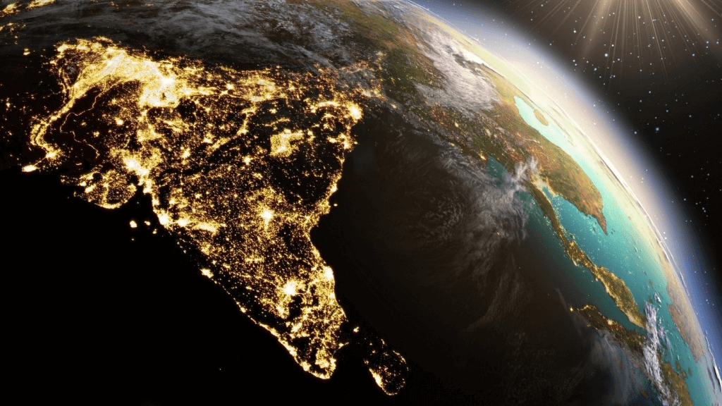
This is the composite map of the world assembled from data acquired by the Suomi NPP satellite in April and October 2012, one of the most beautiful maps of the Earth at night.
Other Satellites
The two satellites, DMSP-OLS & Suomi NPP-VIIRS have shown their effectiveness in various domains and applications related to studying human-related activities and environmental impacts over various areas but are having coarser resolution. On the other hand, finer resolution imageries can surely open up new scenarios and opportunities in this domain. Currently, various satellites and sensors having a higher comparative capability of detecting Night Time Lights (NTL) and spatial resolution have been launched and a few are scheduled to be launched soon.
One of the sources of such Night Time Lights (NTL) datasets with the finer resolution is the images of the earth at night captured by the astronauts on the ISS (International Space Station). Commercial satellite EROS-B provides the 1st Nighttime imagery from the space which captures and provides very fine resolution NTL data (about 0.7m) in 2013 with 10 bits dynamic range and having a spectral wavelength of 0.5 to 0.9 μm. Another commercial satellite launched in the year 2017 is from China which is JL1-3B having finer spatial resolution. It enables multispectral imageries (R, G, B) having a resolution of 0.92m with a potential to detect low lights. All these satellites are of finer spatial resolution and can detect very low lightings at night.
[aux_divider width=”medium” style=”dashed” margin_top=”20″ margin_bottom=”20″ extra_classes=””]
We hope this blog was intriguing enough and it might also have developed your interest in such a less explored domain of Remote Sensing. If this has engaged you, you will definitely enjoy reading the upcoming blogs which will throw some light on its applications in various domains. So, stay tuned, and don’t forget to check out the upcoming Quiz regarding the same topic this Saturday.
For more updates on our blogs, quizzes, and activities, keep checking our website and do follow us on our social media pages.

Dear Sir,
Hope you are well. I am facing some problems with these questions. Please, help me to find the solution in your free time.
Can you please tell me why the satellite measures the nighttime SST along with daytime? What are the scientific applications of measuring daytime and nighttime SST in the ocean? What are the causes for varying the daytime and nighttime SST? Is it possible night SST is higher than SST and when?
If you suggest books or papers regarding this, that will be highly appreciated.
Thanks
Rony